Red Rock Canyon Gold Project – Cochise County, Arizona
“The (IP) geophysical test performed in July 2025 has proven highly successful in detecting and characterizing gold-bearing veins.” October 21, 2025
“The most recent Bonanza grades of 107.5 g/t and 60.0 g/t recovered from sampling along the RRC high grade zone have extended known mineralization by another 100’, along with numerous other gold bearing structures.” January 22, 2025
“Liberty Star Finds Bonanza Grade Gold Samples up to 85.8 g/t over 1’ at the Red Rock Canyon Gold Exploration Property, SE Arizona” July 9,2024
In November, 2020 Liberty Star announced the identification of potentially exploitable gold mineralization in its wholly owned State of Arizona Mineral Exploration Permits (MEPs) land located in the area locally recognized as Red Rock Canyon, contiguous with and immediately north of drill Target 1, within the Hay Mountain Project.
Click to view report
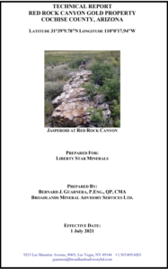
In May & July 2021, the Company received a technical study, the Red Rock Canyon Gold Property Technical Report. The revised Report includes additional historic geophysics and drilling data discovered since the original report was released, May 21, 2021. Report author Barney Guarnera P.Eng., QP, CMA included information and maps from drilling programs from 1999 and 2004 indicating the presence of “a substantial aeromag high approximately 3.5 miles long, probably representing a porphyry copper-gold style intrusive at relatively shallow depth.” Also, “This hidden body is surrounded by a distal sub-micron gold halo symmetrically arranged around the magnetic high (values as high as 1.5 ounces have been obtained from silicified zones at the surface in the limestone host rock).” Drilling records from 2004 show drill holes currently within the Company’s Red Rock Canyon MEP block had several zones of gold mineralization in each hole drilled. Guarnera finds the data and mapping from that time confirm his opinion “that the mineralizing fluids invaded fracture and shear zones and are probably outliers of a deeper-seated gold deposit.” (p. 18)
“According to the Technical Report: Red Rock Canyon Gold Property Cochise County, Arizona, based upon the historic information, the RRC Project may possess commercially important gold deposits on its Mineral Exploration Permits (MEPs) since the historic drill holes contain intercepts that would today be economic gold grades. The Liberty Star geochemical sampling results affirm these findings.” (11/08/2021)
View: 2020 – 2021 ALS/USA Inc. Geochem Assay Tables – Red Rock Canyon Gold Project
2024 – Bonanza grade gold
Preliminary surface exploration on the Red Rock MEPs advances the Company’s knowledge of the porphyry system signature associated with magnetic highs at, and adjacent to the north of, Target 1, and represent the expansion of biogeochemical, surface rock sampling, and x-ray fluorescence (XRF) work continuing at Target 1 and on the anticipated gold halo likely associated with the indicated porphyry center.
Liberty Star’s Field Manager Jay Crawford and team have been conducting a channel sampling program across the gold bearing jasperoid lenses throughout the RRC property. The initial results were enlightening and exciting given several bonanza grade assay results. Chief Geologist Jim Bryce finds “The grades we have seen to date indicate the presence of a broad, epithermal gold system within the RRC boundaries. This system is almost certainly related to the suspected copper/gold porphyry system nearby in the Hay Mountain property.”
In the January 2025 summary of the 2024 channel sampling work Geologist Jim Bryce noted:
- Bonanza grades of 107.5 g/t and 60.0 g/t recovered from sampling along the RRC high grade zone have extended known mineralization by another 100’, along with numerous other gold bearing structures
- GIS map work by the company shows the main high-grade zone, along with parallel and related gold bearing structures within the RRC Project area
- Current sampling has not only extended the length of the known high-grade zone but also discovered 6 other lenses of jasperoids running at greater than 0.5 g/t Au over more than 2’ widths.
Key Highlights from IP Test Survey (Oct 21, 2025)
The three major takeaways from the IP test demonstrate:
1. Gold-bearing veins are readily detected, easily mapped, and can be characterized with electrical geophysics.
2. The gold-bearing veins exhibit higher resistivity than the hosting limestone due to their siliceous, jasperoidal character, making them detectable using simple resistivity even where soil cover has rendered them invisible.
3. Additionally, the gold-bearing veins display higher IP values than the hosting limestone, confirming their association with sulfide mineralization including pyrite and arsenopyrite, characteristic of Carlin-style deposits.
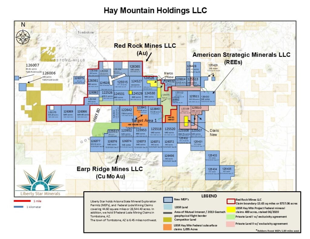
Updated Map | Hay Mountain Holdings LLC April, 2026
Centralized oversight of all mineral assets all mineral holdings are consolidated under Liberty Star Hay Mountain Holdings LLC. Red Rock Mines, LLC, a wholly owned subsidiary was created to advance and highlight the exceptional gold resource opportunity.
Hay Mountain Project
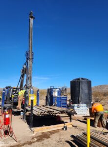
Hay Mountain Project – Diamond Core Drill Program – Dec, 2023
KEY FACTORS
1. Potential for discovery of a high grade and large sediment and porphyry hosted copper, gold, and moly ore body of the same type as the nearby Bisbee deposit and other commercially important ore bodies throughout southeast Arizona
2. Multiple targets over copper- molybdenum-gold –lead anomalies have been plotted using sophisticated ground studies including rock-chip, soil and vegetation geochemical samples assayed for 64 elements by a Certified Assay Laboratory with normal Quality Assurance Quality Control and normal security & record keeping of samples per NI-43-101 requirements, airborne ZTEM geophysical surveys by Certified Geophysicists – Geotech Ltd., also 43-101 compliant, producing magnetic and electromagnetic data and NI-43-101 compliant technical reports from a Certified Geophysicist/ Geologist. XRF surface analysis is ongoing with interesting results that compare to the vegetation geochemistry previously taken
3. Discovery of surface outcrops suggests near surface targets, significantly lowering development time and costs
4. Multiple drill targets selected for diamond core drilling
5. Drilling permits in hand
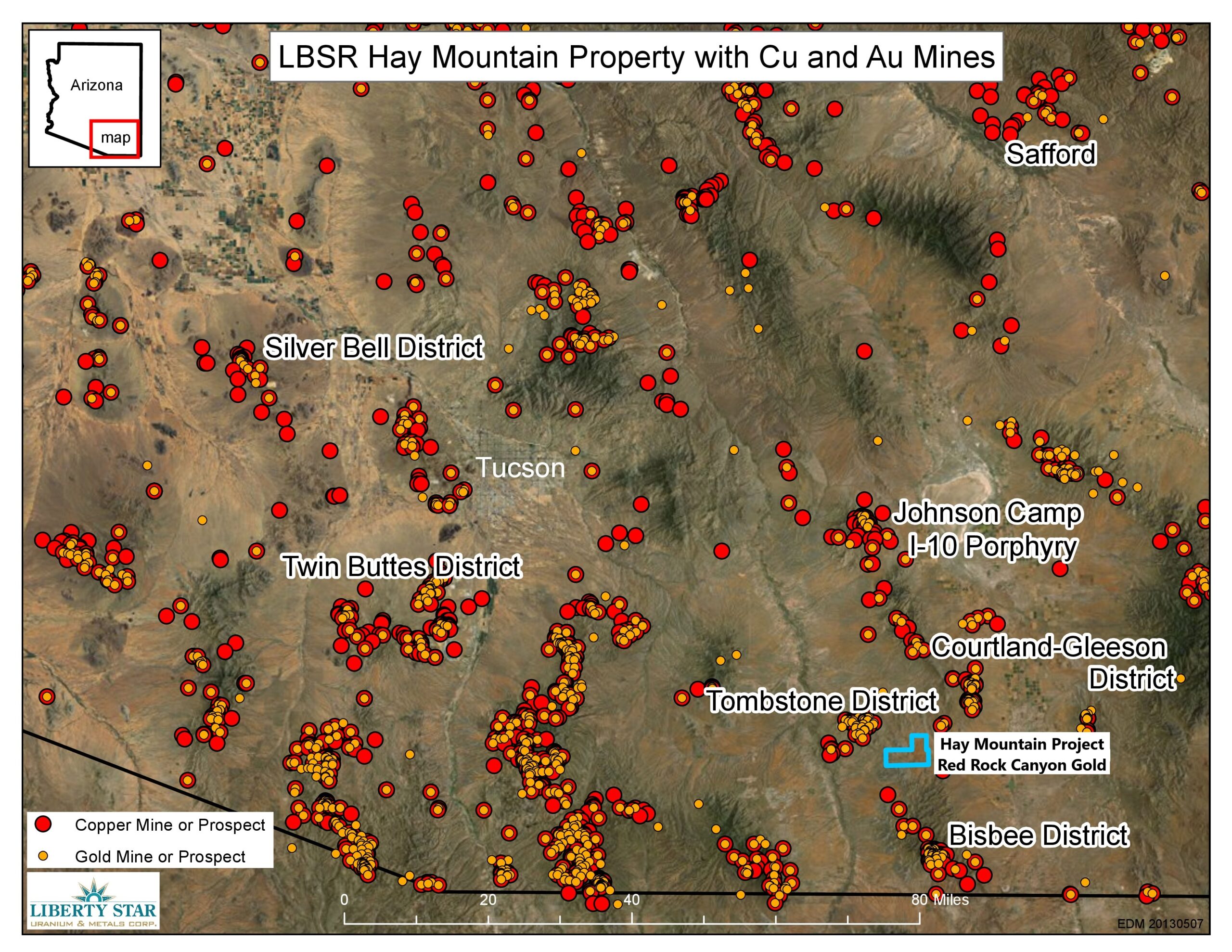
The Tombstone Mining District (“TMD” “Tombstone”): hosts Liberty Star’s premiere multi target property: The Hay Mountain Project. The TMD initially consisted of 33 unpatented federal lode mining claims over a projected covered porphyry copper mineral center in Cochise County, Arizona. In 2011 and 2012 more USBLM claims and Arizona Mining Exploration Permits were added after the discovery of a large multimodal anomaly over a large covered porphyry copper mineral center within the larger TMD area. Currently, the TMD, including the Hay Mountain Project, entails a 42 square mile area of interest. The company holds both federal lode mining claims and Arizona Mineral Exploration Permits within this larger area of interest.
Mining throughout the region began in the late 19th Century and led to the rise of legendary boom town Tombstone, Arizona. Many of these mining sites, including what is now Liberty Star’s land, reside within or adjacent to a large volcanic and intrusive geologic feature known as a caldera. These caldera structures are present throughout southern Arizona, making the region one of the richest porphyry copper areas on the planet. By 1938 exploration and development of the Tombstone Mining District in this area was stalled by altered sedimentary rock (hornfels) that was too hard for the drill technology of the day(churn drills).
Through geochemical sampling and computer modeling, a compelling drill target for a very large limestone hosted porphyry copper-replacement deposit was discovered. If exploration is successful, mining projected for this target would be underground, open-pit, and/or open pit for heap-leach, or in place leach (in-situ) and could produce copper, moly, gold, silver, lead, zinc and potentially other by product metals. While there are no drilled mineral resources on this property, it is adjacent to the old historic Tombstone Consolidated mines and the target is defined by technical work to allow an immediate start to drill testing. The Tombstone mining district has a well-developed infrastructure and enjoys sunny skies over 300 days a year, ideal for year round exploration and mining activities.
In mid March, 2011 Liberty Star contracted SRK Consulting to prepare technical reports over three areas within the Tombstone Project : Hay Mountain, Tombstone South and Walnut Creek. Members of SRK’s engineering/scientific staff supervised by Qualified Person and SRK’s Tucson Office Principal Geologist Corolla Hoag, and geologist Dr. Jan Rasmussen have visited the Tombstone property. Their information combined with the previously gathered geochemical, geophysical and computer modeling data underwent a thorough technical analysis. The resulting technical reports concluded that all three claim blocks were worthy of further exploration work.
TMD/Hay Mountain geochem indicated minerals: Cu Au Mo Mn Zn Pb Ag Co Ni REEs
In 2011 extensive geochemical sampling at Hay Mountain rendered approximately 1,800 soil/rock/vegetation samples which were analyzed for 64 elements at a certified analytical facility in Vancouver, British Columbia. Expected markers for porphyry copper, gold, moly, silver and zinc were present. The geochemical data also yielded the unexpected presence of four of seventeen Rare Earth Elements (REEs).
Liberty Star contracted Geotech Ltd. to run a ZTEM airborne electromagnetic survey over the Hay Mountain area in 2013. The final draft report has been submitted to Liberty Star concluding :
- 1. There are as many as 10 meaningful targets within the Hay Mountain Project area.
- 2. Hay Mountain contains a major anomaly centered on the geochem anomaly reported by Liberty Star.
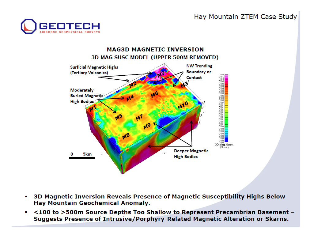
From the “Executive Summary” Summary Interpretation Report on a Helicopter-Borne Z-Axis Tipper Electromagnetic (ZTEM) and Aeromagnetic Geophysical Survey: The Hay Mountain Project Tombstone Mining District, Cochise County, Arizona For: Liberty Star Uranium & Metals Corp.:”
“The Hay Mountain Property is mainly underlain by a thick sequence of Paleozoic quartzite, limestone and siltstones, but potentially hosts buried porphyry copper deposits at structural intersections and under basin-fill formations. There is additional potential for polymetallic carbonate-hosted replacement deposits (CRD), as well as shallow chalcocite blanket porphyry type deposits and also skarn type porphyry copper deposits. Previous soil and vegetation geochemical surveys have identified a coincident Au-Pb-Cu anomaly and larger Mo-halo in the center of the property. The objective of the ZTEM surveys is to identify favourable magnetic and resistivity signatures related to potentially more deeply buried porphyry copper, CRD/skarn and chalcocite replacement deposits at Hay Mountain. The Magnetic surveys have determined that Hay Mountain hosts a large dominant magnetic high that lies buried below the Paleozoic sediments is centered over the Liberty Star geochemical anomaly and remains open to the south…As many as ten (10) magnetic anomalies have been defined.” (12/11/2013)
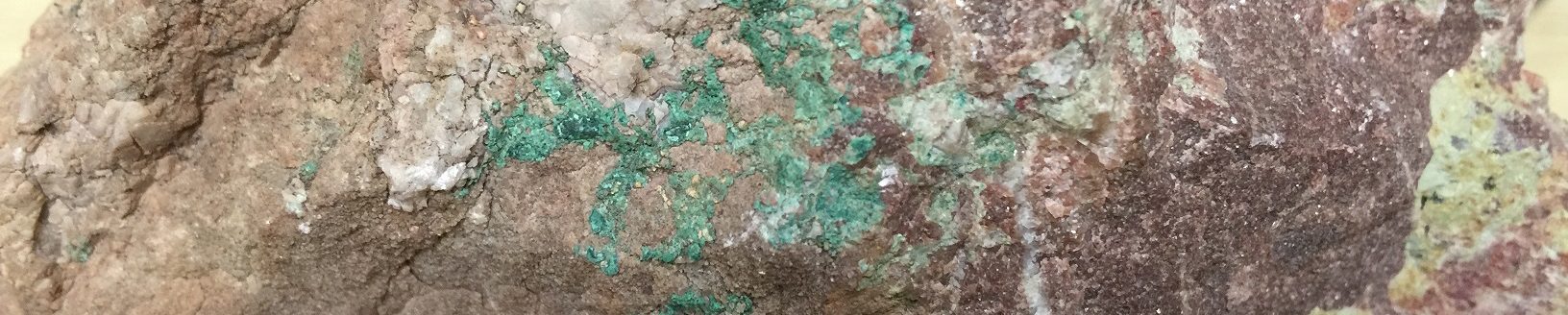
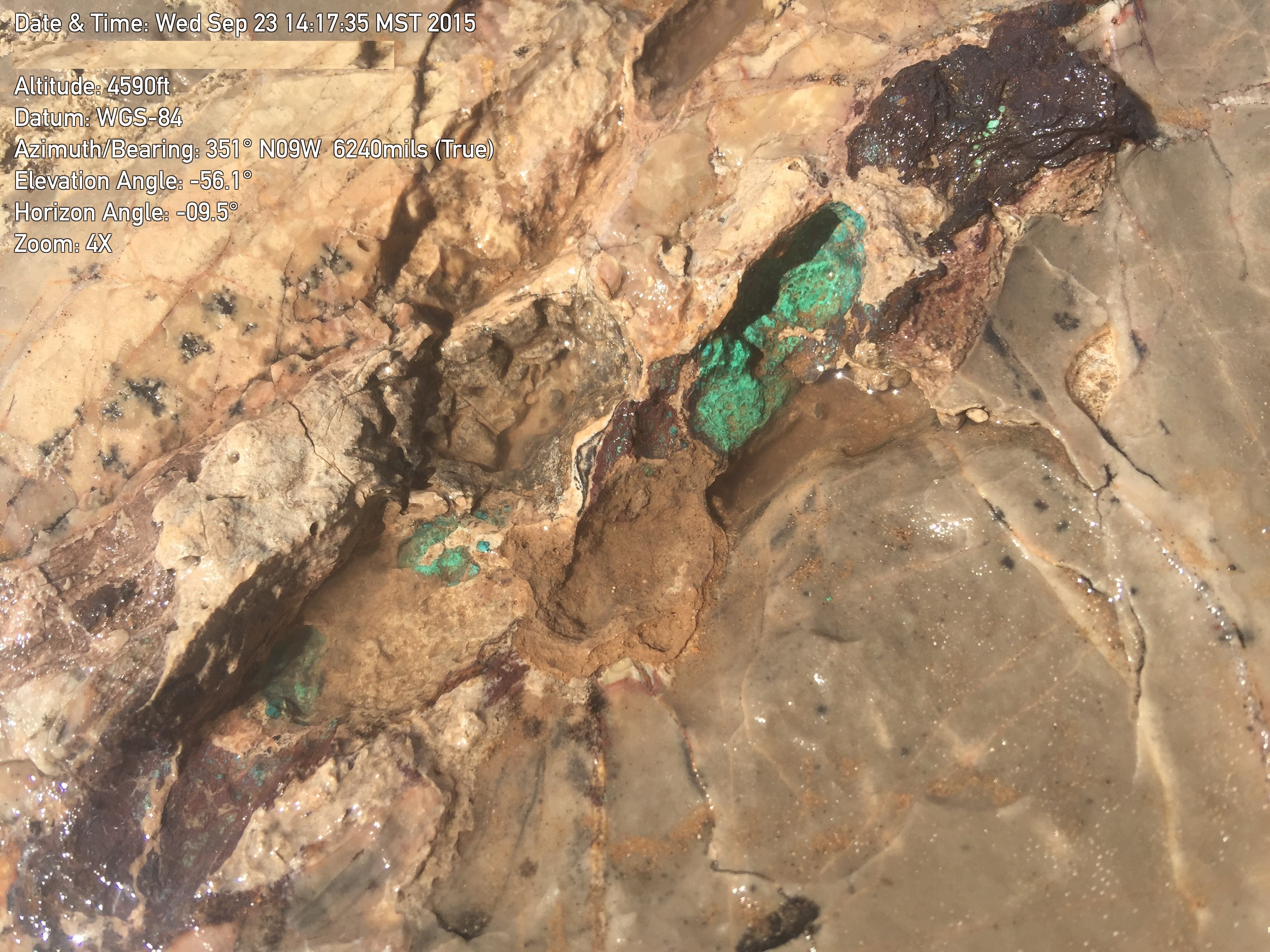
On October 7, 2014 Liberty Star announced “New outcrops have been discovered in the main porphyry copper alteration zone target within the geochemical and geophysical zone that did not appear on any current geologic maps. Additional geologic work is ongoing to define the location and alteration of these outcrops which so far consist of silicification and brecciated (broken) silicified limestone with leached capping. Green copper oxide (chrysocolla) was identified in a very small area, but this is the first visible copper mineralization we have seen in the project surface area to date. All the copper and other metal anomalies are from trace element geochemistry and do not outcrop but are from depth where they are not visible and able to be detected except geochemically. The alteration seen recently in newly identified low outcrops is what would be expected on the edge of a skarn hosted porphyry system.” (NR 189)
By September 2015 the Company announced the placement of initial drill targets (diamond core drilling) based on recent field work conducted with an XRF analyzer and detailed mapping which found pervasively brecciated limestone, which led to the conclusion that the area called the Chrysocolla Block (where the first discovery of oxide copper in outcrop was made) was misidentified as the Colina limestone. Further evaluation led to the conclusion that the zone was of the lower Earp formation, which is the layer directly below the Colina. A red clay marker bed at the base of the exposed Earp limestone breccia clearly identifies it. Current understanding indicates that the latest targets may bloom into major mineral zones 200 to 400 feet in depth at their intersection with the Horquilla limestone, the major mineral host in the region. Similar outcrops were present throughout the Bisbee mining district 15 miles south.
In late 2018 Liberty Star reported the addition of 8 State of Arizona Mineral Exploration Permits (MEPs) covering approximately 6 square miles and nearly doubling the size of unpatented land holdings for the Hay Mountain Project, including a Carlin style gold component. (Oct 15, 2018)
Hay Mountain Project Presentation by Dr. Alan Wilson click to view presentation
The Hay Mountain Project is located 6.5 miles southeast of Tombstone where we hold Arizona State Mineral Exploration Permits (MEPs), and federal mining Lode Claims covering 16,888.42 acres, accessible by Hwy 80, Davis Rd. and Wild West Road.
In early December 2023 Liberty Star Minerals advanced the exploration process by starting a new drilling program at Earp Ridge|Hay Mountain (deep drilling) and Red Rock Canyon (channeling & shallow drilling). “We’ve talked about drilling for years,” said Pete O’Heeron, Board Chair of Liberty Star. “Engaging a world class drilling service for our first test of our gold and copper properties is an important milestone for Liberty Star. We’ve done the necessary geoscientific studies and now it is time to see the proof of the area’s potential through core analysis.” (11/21/2023)
Drilling at Hay Mountain Target 1 (Earp Ridge) continued through March, 2024 yielding suggestive results for further drilling continuing down the first two holes and near Target 1, also withing the Earp Ridge area. Further phased drilling plans for the area are underway.
“[Liberty Star] has staked an additional 13 mineral exploration permits (MEPs) mining claims…. increasing its total mineralized footprint to approximately 45 square miles. These are in addition to the previously announced MEPs from March 10, 2026….This ranks Hay Mountain Holdings, LLC as the largest mineral footprint in Arizona, not controlled by a large mining company.” April 20, 2026
All mineral holdings are consolidated under Liberty Star Hay Mountain Holdings LLC. Earp Ridge Mines, LLC The multi-mineral claims historically known as Hay Mountain Target 1 & 2 is within, our wholly owned subsidiary, Earp Ridge Mines, LLC. Additional Claim areas within the larger Hay Mountain Holdings LLC will be similarly organized as needed.